
Do you ever wonder how rain is measured? Or how you can accurately predict the occurrence of floods in your area? The answer lies in mastering the art of rainfall measurement. Understanding and properly measuring rainfall is crucial for predicting flood events and implementing effective flood prevention measures.
In this article, we will dive into the world of rainfall measurement and explore the different methods used to measure rainfall, as well as their advantages and limitations. We will also discuss how accurate rainfall data is collected and analyzed to predict floods, and how this information can be used for effective flood prevention.
What is Rainfall Measurement?
Rainfall measurement is the process of recording and quantifying the amount of rain that falls in a specific area over some time. This measurement is important for various reasons, such as agricultural planning, water resource management, and flood prediction.
Traditionally, rainfall was measured using simple tools like rain gauges, which are still widely used today. However, with advancements in technology, more sophisticated methods have been developed to measure and analyze rainfall data accurately.
READ MORE:- Unlocking Potential: Revamping Your Garage
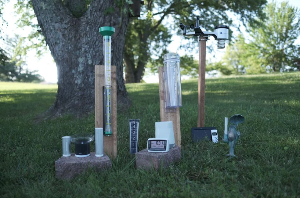
Methods of Rainfall Measurement
There are several methods used to measure rainfall, including manual and automatic techniques. Let’s take a closer look at some of these methods.
Rain Gauges
Rain gauges are the most common and traditional method for measuring rainfall. These devices consist of a cylindrical container with a funnel-shaped top that collects rainwater. The amount of rain collected is measured using markings on the container or by emptying the container and measuring the water’s volume.
Rain gauges are inexpensive, easy to use, and suitable for both manual and automatic measurements. However, their accuracy may be affected by factors such as wind, evaporation, and splashing.
Tipping Bucket Rain Gauges
Tipping bucket rain gauges are a type of rain gauge that uses a tipping mechanism to record rainfall. This mechanism consists of two buckets, each connected to a lever, and a small seesaw that tips from one side to the other every time the bucket fills up.
When a certain amount of rain falls into the gauge, the lever tips over, causing the bucket to empty, and the seesaw switches sides. Each tip of the see-saw corresponds to a specific amount of rain, allowing for accurate measurements.
Weighing Rain Gauges
Weighing rain gauges operate by measuring the weight of the collected rainfall. These devices consist of a storage container suspended above a scale, and every time it rains, the container fills up with water, increasing its weight.
The data recorded can be used to calculate rainfall intensity and duration, as well as to estimate the potential for floods.
Remote Sensing
Remote sensing involves using satellite technology to measure rainfall over a large area. By analyzing the differences in radiation absorption caused by water droplets, remote sensing can estimate the amount of rainfall.
This method is useful for areas where it is difficult to access or install rain gauges and provides an overall view of precipitation patterns over a wide geographical region.
Radar
Using radar technology to measure rainfall is one of the most accurate methods available. Radar level transmitters are typically mounted on radar antennas, which emit pulses of energy and record their reflection off rain droplets.
The time it takes for the pulse to return can be used to estimate rainfall intensity and location accurately. This method is particularly useful in areas where traditional rain gauges may not provide sufficient data, such as in hilly or heavily forested regions.
READ MORE:- How To Effectively Communicate With Your Homeowners Association
The Role of Rainfall Measurement in Flood Prevention
Accurate rainfall measurement is crucial for predicting and preventing floods. By understanding the amount, intensity, and duration of rainfall in a particular area, flood warning systems can be implemented to alert communities of potential danger.
For example, if an area has experienced heavy rainfall over a short period, the data collected by rain gauges or remote sensing can be used to predict potential flooding and trigger evacuation protocols.
Moreover, proper rainfall measurement also allows for the development of effective flood control measures. By analyzing past rainfall data, engineers can design infrastructure such as drainage systems and levees to prevent water from accumulating and causing floods.
Conclusion
In summary, mastering the art of rainfall measurement is essential for effective flood prevention. By understanding the different methods used to measure rainfall and their advantages and limitations, we can accurately predict and prevent floods in our communities. With advancements in technology, we can continue to improve our ability to collect and analyze accurate rainfall data, leading us toward a more flood-resilient future.
Do you have any experience with rainfall measurement or flood prevention measures? Share them with us in the comments below